Much of what occurred on Sept. 11, 2001, was recorded in wrenching close-ups, with video and still cameras surrounding the falling twin towers, the burning Pentagon and the crash site of Flight 93.
But in the days that followed, scientists started pulling back, examining events from vantage points as distant as geostationary orbit, 22,300 miles from Earth.
Using airborne spectrometers like those that have mapped the face of Jupiter, researchers charted potentially toxic dust from the disintegrated towers. Others pored over weather-satellite data to see how the lack of contrails in the planeless skies affected weather patterns.
But in scrutinizing Sept. 11 from aircraft and spacecraft, the researchers also added a wide-field view to the growing archive of indelible imagery from that extraordinary day.
Some are available at a Web site for the National Aeronautics and Space Administration, www.gsfc .nasa.gov.
At NASA's Langley Research Center, in Hampton, Va., Louis Nguyen, a computer engineer, compiled images from the weather-tracking GOES-8 satellite, pulling data recorded over New York City every quarter hour in grainy half-mile-wide pixels.
At 8:45 a.m. on that crystalline morning, one minute before the first plane strikes, the skies are clear and bright. By 9:02 a gray puff hangs over Manhattan. In successive shots, a bright tendril snakes south along the Jersey Shore and by noon spreads into a misty veil, giving no hint of the calamity below.
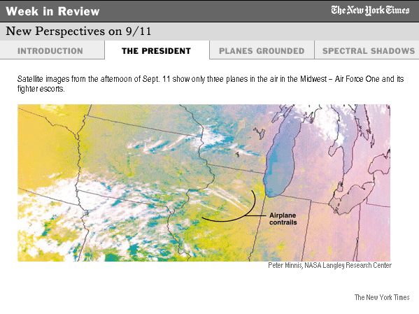
Secretive events later in the day were unexpectedly witnessed.
Another Langley scientist, Dr. Patrick Minnis, who was studying the effect of aircraft contrails on clouds, realized that the three-day aviation ban provided a classic control case - a unique period in which none of the white streaks of condensation from jet engines were thatching the sky.
He began scouring other satellite data to compare jetless and normal conditions.
In one Sept. 11 image, combining visible-light photography and infrared data, he saw three parallel streaks converging and heading east from Nebraska toward Washington.
The time was 5:45 p.m., Eastern time, almost certainly meaning this was an extraordinary portrait of President Bush's fighter-escorted flight from Offutt Air Force Base in Omaha back to Washington.
This is the first time NASA has allowed the image to be published.
Meanwhile, government geologists and space scientists were teaming up to see if their armamentarium of sensors could be of use in probing the remains of the World Trade Center.
From Sept. 16 to Sept. 23, a Twin Otter airplane crossed lower Manhattan with an airborne visible-infrared imaging spectrometer, Aviris, that divines the composition of materials a mile or more below by the way they reflect or absorb sunlight.
Elsewhere, Aviris has been used to scour Superfund toxic sites to map hot spots of harmful compounds, said Robert O. Green, the scientist at NASA's Jet Propulsion Laboratory who is in charge of research with the instrument. Similar devices have scanned Jupiter. "One is on its way to Saturn," he said.
The goal was to map both the heat from buried fires and the composition of dust that carpeted much of the financial district, to help direct the rescue and environmental cleanup crews.
Scientists on the ground collected samples of dust from dozens of spots and analyzed them in laboratories, so the aerial and ground data could be compared to make maps of dust trails of various types.
Other spectrographic readings pinpointed spots where steel beams with asbestos coatings were likely to be. But the airborne instruments recorded few signs of significant asbestos in the dust.
The finding helped confirm that there was no widespread threat of asbestos contamination, Mr. Green said.
The results of the project are compiled in a report on the Web at greenwood.cr.usgs.gov/pub /open-file-reports/ofr-01-0429/.
The aerial spectral survey also unexpectedly created a ghostly imprint of the vanished twin towers.
The heaviest material, concrete and cement dust, lies in a tight band falling southeast from the site of the towers, following the direction of the wind that day.
Just to the east of that band lies a parallel swath of gypsum dust from destroyed wallboard. The lighter material dispersed farther in the wind.
In the images, the dusty vestiges of the buildings - invisible to the unaided eye - cover nearby blocks like an enduring shadow of structures that are no longer there.